Sun map vs shade analysis Infographic


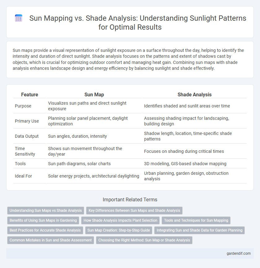
Sun maps provide a visual representation of sunlight exposure on a surface throughout the day, helping to identify the intensity and duration of direct sunlight. Shade analysis focuses on the patterns and extent of shadows cast by objects, which is crucial for optimizing outdoor comfort and managing heat gain. Combining sun maps with shade analysis enhances landscape design and energy efficiency by balancing sunlight and shade effectively.
Table of Comparison
| Feature | Sun Map | Shade Analysis |
|---|---|---|
| Purpose | Visualizes sun paths and direct sunlight exposure | Identifies shaded and sunlit areas over time |
| Primary Use | Planning solar panel placement, daylight optimization | Assessing shading impact for landscaping, building design |
| Data Output | Sun angles, duration, intensity | Shadow length, location, time-specific shade patterns |
| Time Sensitivity | Shows sun movement throughout the day/year | Focuses on shading during critical times |
| Tools | Sun path diagrams, solar charts | 3D modeling, GIS-based shadow mapping |
| Ideal For | Solar energy projects, architectural daylighting | Urban planning, garden design, obstruction analysis |
Understanding Sun Maps vs Shade Analysis
Sun map analysis provides a comprehensive visualization of solar exposure on specific surfaces throughout the day and year, helping identify areas with the most intense sunlight. Shade analysis focuses on mapping shadow patterns cast by buildings or objects, essential for assessing obstructions that reduce solar gain and influence microclimates. Together, these tools enable precise planning for solar energy projects, landscaping, and urban design by optimizing sun exposure and minimizing undesirable shade.
Key Differences Between Sun Maps and Shade Analysis
Sun maps illustrate the intensity and distribution of sunlight exposure across a specific area, highlighting peak sun hours and energy potential for solar installations. Shade analysis identifies obstructions such as trees, buildings, or terrain features that cast shadows, crucial for understanding periods of limited sunlight and optimizing placement of solar panels or landscaping. The key difference lies in sun maps focusing on sunlight availability while shade analysis emphasizes shadow impact throughout the day.
Benefits of Using Sun Maps in Gardening
Sun maps provide precise data on sunlight exposure patterns, enabling gardeners to optimize plant placement for maximum growth and health. By analyzing daily and seasonal variations in sunlight, these maps help prevent under- or overexposure, ensuring plants receive adequate light for photosynthesis. Utilizing sun maps improves water efficiency and reduces the risk of plant stress, leading to higher yields and a more sustainable garden environment.
How Shade Analysis Impacts Plant Selection
Shade analysis determines the intensity and duration of sunlight exposure across different areas, directly influencing plant health and growth patterns. Selecting plants based on precise sun maps ensures optimal photosynthesis, reducing stress and improving resilience in garden designs. Understanding shade variations helps gardeners choose species with appropriate light requirements, enhancing overall biodiversity and sustainability.
Tools and Techniques for Sun Mapping
Sun mapping employs tools such as GIS software, drone imaging, and fisheye photography to capture accurate sunlight patterns over specific areas. Techniques like time-lapse photography and solar path diagrams are used to analyze shade distribution and optimize building orientation or landscaping. Advanced algorithms process temporal solar data to generate detailed sun shade maps, enhancing energy efficiency and comfort in urban planning.
Best Practices for Accurate Shade Analysis
Effective shade analysis requires precise sun map data, integrating topographical and structural elements for accurate solar exposure modeling. High-resolution 3D models combined with geospatial coordinates enhance the reliability of shadow projections throughout different times of the day and year. Utilizing validated algorithms and real-time solar position data ensures comprehensive assessment for optimal building placement and energy efficiency.
Sun Map Creation: Step-by-Step Guide
Sun Map creation involves capturing site-specific solar data through precise measurements of sunlight angles and durations using tools like solar pathfinders or smartphone apps. Integrating geographic coordinates with climate data enables accurate visualization of sun exposure patterns over daily and seasonal cycles. This detailed solar analysis supports optimized placement of solar panels, landscaping, and architectural elements to maximize energy efficiency and comfort.
Integrating Sun and Shade Data for Garden Planning
Integrating sun map and shade analysis data enhances garden planning by accurately identifying optimal plant placement based on sunlight exposure patterns. Utilizing geographic information system (GIS) technology combined with real-time solar angle tracking enables precise delineation of sunlit and shaded zones throughout the day and seasons. This approach improves growth conditions by aligning plant species' sunlight requirements with specific garden microclimates, maximizing photosynthesis and overall garden health.
Common Mistakes in Sun and Shade Assessment
Common mistakes in sun and shade assessment often include relying solely on static sun maps that fail to account for seasonal variations and dynamic environmental factors. Inaccurate placement of measurement points and ignoring local obstructions such as trees or buildings can lead to misleading conclusions about sunlight exposure. Incorporating comprehensive shade analysis tools that consider temporal changes ensures a more precise evaluation for optimal landscape and architectural planning.
Choosing the Right Method: Sun Map or Shade Analysis
Choosing between sun map and shade analysis depends on the specific project goals and environmental conditions. Sun maps provide detailed solar exposure patterns throughout the day, ideal for optimizing solar panel placement or identifying sunlit areas for gardening. Shade analysis, on the other hand, emphasizes identifying shadowed zones to prevent overheating and improve building energy efficiency.
Sun map vs shade analysis Infographic