Microclimate mapping vs macroclimate assessment Infographic

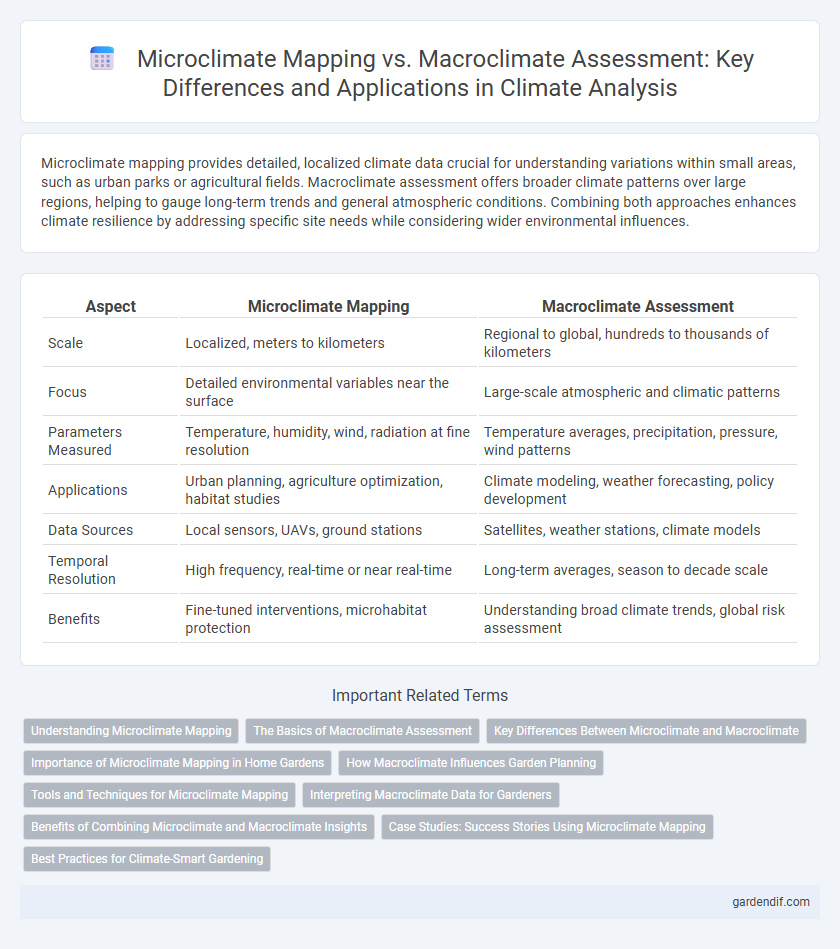
Microclimate mapping provides detailed, localized climate data crucial for understanding variations within small areas, such as urban parks or agricultural fields. Macroclimate assessment offers broader climate patterns over large regions, helping to gauge long-term trends and general atmospheric conditions. Combining both approaches enhances climate resilience by addressing specific site needs while considering wider environmental influences.
Table of Comparison
| Aspect | Microclimate Mapping | Macroclimate Assessment |
|---|---|---|
| Scale | Localized, meters to kilometers | Regional to global, hundreds to thousands of kilometers |
| Focus | Detailed environmental variables near the surface | Large-scale atmospheric and climatic patterns |
| Parameters Measured | Temperature, humidity, wind, radiation at fine resolution | Temperature averages, precipitation, pressure, wind patterns |
| Applications | Urban planning, agriculture optimization, habitat studies | Climate modeling, weather forecasting, policy development |
| Data Sources | Local sensors, UAVs, ground stations | Satellites, weather stations, climate models |
| Temporal Resolution | High frequency, real-time or near real-time | Long-term averages, season to decade scale |
| Benefits | Fine-tuned interventions, microhabitat protection | Understanding broad climate trends, global risk assessment |
Understanding Microclimate Mapping
Microclimate mapping involves detailed spatial analysis of localized climate variables such as temperature, humidity, wind patterns, and solar radiation within small geographic areas, highlighting the impact of terrain, vegetation, and urban structures. Unlike macroclimate assessment that provides broad regional climate trends, microclimate mapping offers granular insights crucial for precision agriculture, urban planning, and ecosystem management. Advanced remote sensing technologies, GIS tools, and high-resolution sensor networks enhance accuracy in capturing microclimate variability, enabling more effective climate adaptation strategies.
The Basics of Macroclimate Assessment
Macroclimate assessment involves analyzing large-scale atmospheric conditions such as regional temperature patterns, prevailing wind directions, and seasonal precipitation trends to understand broad climate characteristics. It relies on meteorological data gathered from weather stations, satellites, and climate models to provide insights into climate zones and long-term environmental changes. This foundational approach informs environmental planning, agriculture, and climate adaptation strategies by identifying overarching climatic influences on ecosystems.
Key Differences Between Microclimate and Macroclimate
Microclimate mapping examines localized atmospheric conditions within small areas, such as urban neighborhoods or forest patches, by measuring variables like temperature, humidity, and wind patterns at high spatial resolution. In contrast, macroclimate assessment analyzes broader climate zones over extensive regions or continents, relying on aggregated climate data from weather stations and satellite observations. Key differences include spatial scale, with microclimates spanning meters to kilometers and macroclimates covering hundreds to thousands of kilometers, and temporal variability, where microclimates fluctuate rapidly while macroclimates reflect long-term climatic trends.
Importance of Microclimate Mapping in Home Gardens
Microclimate mapping provides detailed insights into temperature, humidity, sunlight, and wind variations within home gardens, enabling precise plant placement and optimized growth conditions. Unlike broad macroclimate assessments, this localized data helps gardeners mitigate microenvironmental stresses and enhance biodiversity. Implementing microclimate mapping improves water use efficiency and pest management tailored to specific garden zones.
How Macroclimate Influences Garden Planning
Macroclimate assessment provides essential data on regional temperature, precipitation, and seasonal weather patterns, informing gardeners about the broader climate conditions affecting plant growth. Understanding macroclimate zones helps select climate-appropriate plant species that can thrive in long-term conditions and resist local pests and diseases. Macroclimate insights guide irrigation planning and frost protection, ensuring sustainable and resilient garden designs aligned with regional climate trends.
Tools and Techniques for Microclimate Mapping
Microclimate mapping employs high-resolution tools such as remote sensing, GIS (Geographic Information Systems), and in-situ sensor networks to capture localized climatic variations at fine spatial scales. Techniques like LiDAR (Light Detection and Ranging) and UAV (Unmanned Aerial Vehicles) enable detailed terrain and vegetation analysis, essential for understanding microclimate patterns. These methods provide granular data critical for urban planning, agriculture, and biodiversity conservation, surpassing the broader scope of macroclimate assessments.
Interpreting Macroclimate Data for Gardeners
Gardeners benefit from interpreting macroclimate data by understanding regional temperature patterns, precipitation trends, and frost dates, which guide plant selection and planting schedules. Microclimate mapping refines this information by capturing localized variations in sunlight, wind exposure, and humidity within a garden. Integrating both macroclimate assessment and microclimate insights enables precise garden planning and optimized plant health.
Benefits of Combining Microclimate and Macroclimate Insights
Combining microclimate mapping with macroclimate assessment enhances the accuracy of climate modeling by integrating localized environmental variations with broader regional climate trends. This fusion supports precision agriculture, urban planning, and ecosystem management by offering insights into temperature fluctuations, humidity levels, and wind patterns at multiple scales. Leveraging both micro and macroclimate data enables more effective adaptation strategies to climate change and improves resource allocation for sustainability initiatives.
Case Studies: Success Stories Using Microclimate Mapping
Microclimate mapping has enabled precise monitoring of local temperature variations and humidity levels, as demonstrated in the urban heat island mitigation project in Phoenix, Arizona, where targeted tree planting reduced neighborhood temperatures by up to 3degC. In agricultural settings, microclimate mapping in the Napa Valley vineyard allowed for optimized irrigation schedules and improved grape yields by identifying soil moisture disparities within small plots. These case studies highlight the superior granularity of microclimate data over broader macroclimate assessments, facilitating tailored climate adaptation strategies.
Best Practices for Climate-Smart Gardening
Microclimate mapping offers granular insights into temperature, humidity, and sunlight variations within small garden spaces, facilitating targeted planting strategies that enhance plant resilience and water efficiency. Macroclimate assessment provides a broader regional context, informing gardeners of seasonal weather patterns and extreme event risks essential for long-term planning. Combining both approaches enables climate-smart gardeners to optimize species selection and irrigation practices, promoting sustainable growth and biodiversity.
Microclimate mapping vs macroclimate assessment Infographic